
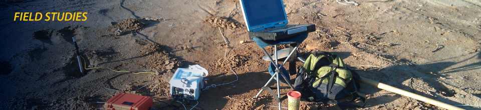
field studies demonstrate flexibility of new ZEN™ system
ZEN Clearly Detects Signal Generated by Buried Pipeline at 30m Depth
Successful field test of ZEN receivers for marine pipeline location
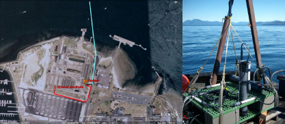
The first survey completed using ZEN™ receivers was performed in the summer of 2010 as part of an effort to locate a buried submarine pipeline for the Port of Newport in Yaquina Bay, Oregon.
Accurate location of the pipeline was necessary as part of a development project to upgrade the pier used by the NOAA fleet. This pipeline is in 15 meters of seawater and buried another 15 meters below the ocean bottom. Earlier efforts to locate it using conventional pipeline locating tools had not been successful.
A team from Oregon State University and SAIC collected data using a jointly-developed marine instrument system built with a ZEN receiver and Zonge transmitter.
One pole of a Zonge GGT-3™ transmitter was connected to the exposed pipeline on shore and the second to a remote electrode. Approximately 1.1 kilowatts of energy was driven through the steel pipeline at a frequency of 256 Hz. A sensor package, consisting of 3 magnetic field sensors and a 3-channel receiver was towed in lines perpendicular to the expected trace of the pipeline. Measurements were made of each magnetic field component a sample rate of 1024 Hz.
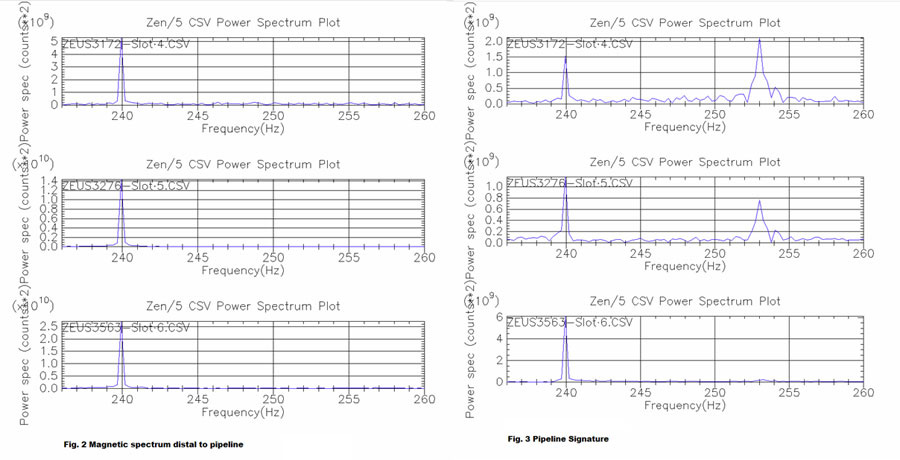
 As expected, there was no signature from the transmitter away from the pipeline. Figure 2 is a narrow band spectrogram, from 235 Hz to 260 Hz, of the power from the X, Y, and Z magnetic field sensors. While there is no response from the transmitter in this area, a significant peak can be seen at 240 Hz, the fourth harmonic of the local power grid.
Directly above the pipeline, we see a significant response in both horizontal magnetic field components, and a null in the vertical field, at the transmitter injection frequency (Figure 3). This crossover in the vertical magnetic field is consistent with the field generated by a line current source. The magnitude of the field generated by the transmitter is roughly similar to the 240 Hz power line harmonic.
This test, in which the ZEN receiver system was easily packaged for use in the marine environment and deployed in a novel configuration, demonstrated the flexibility of the new receiver design and the opportunity for further development.
ZEN Collects Quality Natural-Source Data Amid Heavy Cultural Noise
Magnetotellurics (MT) groundwater mapping in the desert using new ZEN receivers
October, 2011. Zonge International field personnel are acquiring full tensor magnetotelluric data in the Ajo Valley, west of Tucson, Arizona. The area contains the well field providing a significant part of the water supply for the city and is characterized by a deep alluvial deposit (greater than 1 km deep) overlying a crystalline basement.
This area of mixed land use — small farms, suburban homes, industrial developments — and diverse cultural noise is an excellent testing ground for the ZEN 32-bit dynamic range. Early results document the ability to collect quality data in this difficult environment using the ZEN Acquisition System.
 Zonge is using tensor MT stations at approximately 1 mile (1.5 km) spacing in an area previously investigated by the US Geological Survey using gravity methods. Multiple stations are deployed daily using a very small crew of only one or two people.
Data is collected in the range of 0.001 to 1024 Hz with a two-channel remote reference located approximately 20 km from the survey area.
The goal of the survey is to collect resistivity measurements that will hopefully add to the understanding of the hydrological system and the interaction of the graben bounding faults with the fluid flow. An accurate geological model of the area is critical for Tucson given that this is a groundwater recharge area of the local aquifer.
IN DEVELOPMENT
- – Multiplexer for low-power option
- – Receiver Board and sensors for radiofrequency magnetotelluric (RFMT) investigations